


Hardware components | ||||||
 |
| × | 1 | |||
| × | 1 | ||||
Now is the moment to give a definition of what a smart city is. Like its forebears, smart cities today have all the ingredients necessary to materialise. Increased population and technological advancements that permitted and drove a shift in living conditions were the driving forces behind the cities that emerged from the agrarian revolution and later the industrial revolution. These same characteristics exist in the modern metropolis, but on a much greater scale since, as was already noted, the world's population is expanding exponentially and we need strategies for coping with it.
One of the main reasons to improve our current city models is the strain that population has on available resources. And the necessary technology is now available in the shape of hyperconnectivity, more affordable and improved sensors, artificial intelligence, and data analytics. The data is the key here; it is the new force in the contemporary smart city. The centre of gravity for the smart city will be data, or more specifically, the analysis and use of these data. In order to improve key elements and functions of cities, such as monitoring water and air quality, waste management, parking, lights, and cars, a smart city should have a variety of technological solutions.
With the use of smart bins designed using, we aim to improve smart trash management in a city in order to speed up the process, lessen traffic and pollution, and aid in improving energy efficiency.
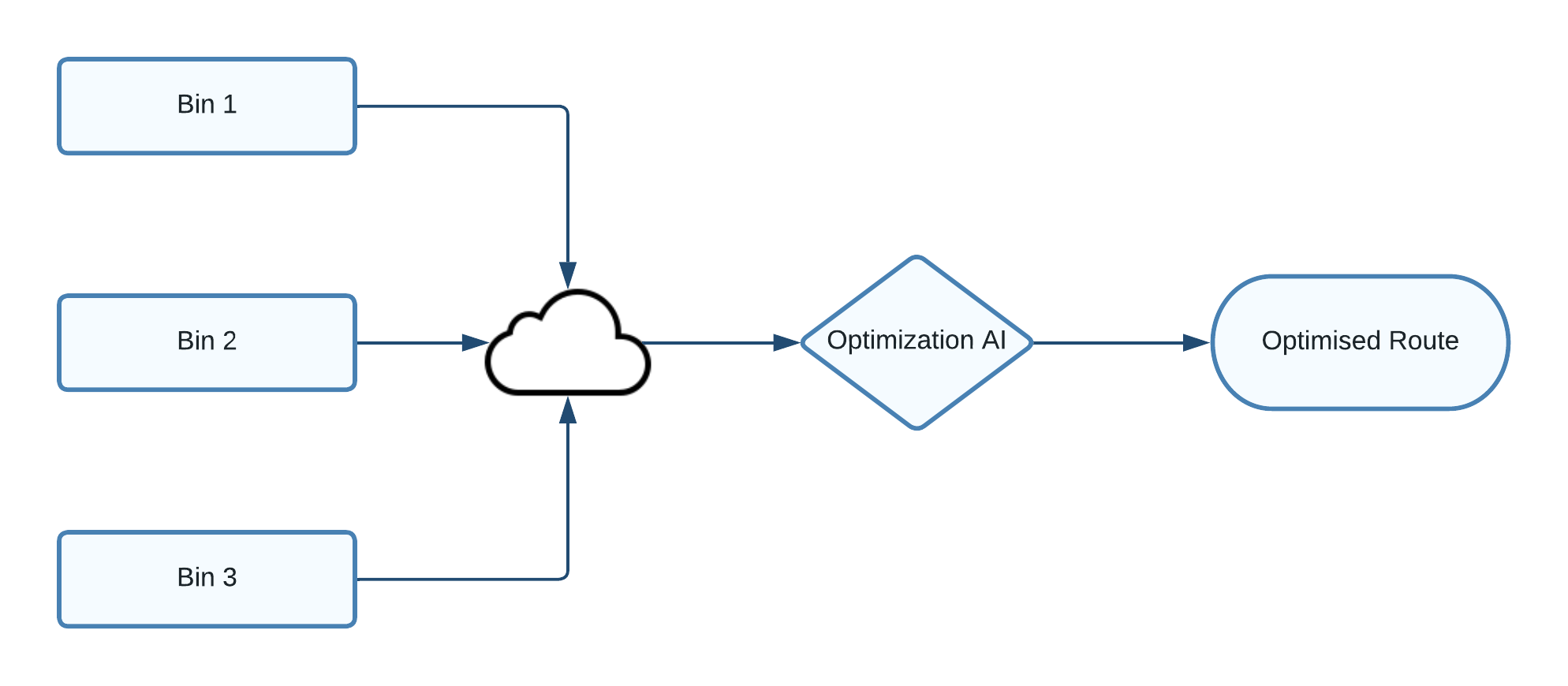
Non-optimized garbage collection truck routes are one of the biggest problems in waste management. Unoptimized truck routes result in high fuel use and traffic jams in heavily populated cities. Additionally, as a result, some bins may probably end up being overfilled while others could end up being underfilled. In order to reduce traffic jams and overuse of fuel, we are truly going to address the optimization of garbage collection truck routes.
How Does It WorkThe project will proceed in this manner. In order to continuously monitor the fill level within the trash cans, fill level sensors are connected to each one. The data is uploaded to the cloud at a certain time each morning (let's say 7 am). An appropriate gadget allows a garbage truck driver to retrieve data from the node and optimise the truck route.
1.Seeed Wio Terminal
The Wio Terminal, ATSAMD51-based microcontroller is equipped with a 2.4" LCD screen, inbuilt IMU(LIS3DHTR), microphone, buzzer, microSD card slot, light sensor, and infrared emitter in addition to wireless connectivity supplied by Realtek RTL8720DN (IR 940nm). The Realtek RTL8720DN chip provides Bluetooth and Wi-Fi, acting as the foundation for IoT initiatives.
2. Time of Flight Distance Sensor, VL53L0X
Grove's Time of Flight Distance Sensor, Model VL53L0X, is a long-range, high-speed, high-accuracy ToF distance sensor.
In contrast to traditional technologies, the VL53L0X is a new generation Time-of-Flight (ToF) laser ranging module contained in the smallest package currently available on the market. It provides accurate distance measuring regardless of the target reflectances. It can measure absolute distances of up to 2 metres, setting a new standard for performance levels and allowing for a wide range of novel applications.
Software Components1. Arduino IDE Setup For Wio Terminal- Download and Install the Arduino IDE: We are using Arduino IDE to programme the Wio Terminal, so we need to install it on our computer first. Click here to download Arduino IDE
- Install Wio Terminal: Arduino IDE comes with official boards loaded from the Arduinio. So In order to program Wio Terminal we need to install the Wio Terminal Board packages and definition on the Arduino IDE.
- Add Additional Boards Manager URL: For that Open your Arduino IDE, click on File > Preferences, and copy below URL to Additional Boards Manager URLs
https://files.seeedstudio.com/arduino/package_seeeduino_boards_index.json- Select your board and port: For that, you'll need to select the entry in the Tools > Board menu that corresponds to your Arduino. Selecting the Wio Terminal.
- Select the serial device of the Wio Terminal board from the Tools -> Port menu.
- Create a brand new Wio Terminal project using PlatformIO. Call this project
proximity-sensor. Add code in thesetupfunction to configure the serial port. - Add a library dependency for the Seeed Grove time of flight distance sensor library to the projects
platformio.inifile:
lib_deps =
seeed-studio/Grove Ranging sensor - VL53L0X @ ^1.1.1- In
main.cpp, add the following below the existing include directives to declare an instance of theSeeed_vl53l0xclass to interact with the time of flight sensor:
#include "Seeed_vl53l0x.h"

Seeed_vl53l0x VL53L0X;- Add the following to the bottom of the
setupfunction to initialize the sensor:
VL53L0X.VL53L0X_common_init();
VL53L0X.VL53L0X_high_accuracy_ranging_init();- In the
loopfunction, read a value from the sensor:
VL53L0X_RangingMeasurementData_t RangingMeasurementData;
memset(&RangingMeasurementData, 0, sizeof(VL53L0X_RangingMeasurementData_t));

VL53L0X.PerformSingleRangingMeasurement(&RangingMeasurementData);
This code initializes a data structure to read data into, then passes it into the PerformSingleRangingMeasurement method where it will be populated with the distance measurement.
Below this, write out the distance measurement, then delay for 1 second:
Serial.print("Distance = ");
Serial.print(RangingMeasurementData.RangeMilliMeter);
Serial.println(" mm");

delay(1000);- Build, upload and run this code. You will be able to see distance measurements with the serial monitor. Position objects near the sensor and you will see the distance measurement:
Distance = 29 mm
Distance = 28 mm
Distance = 30 mm
Distance = 151 mmOnce we have our data in the serial monitor, now it's time to upload the data to google cloud. Follow this link to setup google cloud and connect Wio Terminal to Google Cloud IoT.
ConclusionBecause the vehicle has ingrained itself so deeply into our lives, many of us fail to see the significant role it has played in one of the world's most urgent issues: global warming. The planet's temperature rises as a result of greenhouse gases' ability to trap heat in the atmosphere. Most of the increase in atmospheric greenhouse gases during the past 150 years has been attributed to human activity, such as the burning of fossil fuels for transportation, electricity, and heating.
It has been discovered that global warming affects the ecosystem, the weather, and our health. AI is already being used to optimize industrial and residential energy intake and reduce their respective carbon footprints. It is also being used to optimize carrier routes, predict and forecast supply and demand, predict and forecast maintenance, and manage autonomous transportation. All these optimizations will directly and indirectly lead to reductions in carbon footprints and a cleaner, safer and greener earth for the future.


Comments
Please log in or sign up to comment.